Research Topics

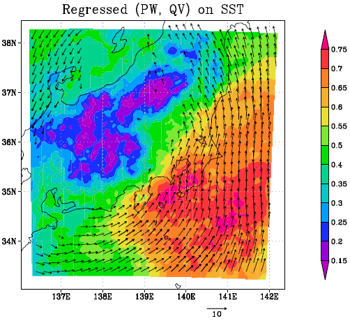
Fig. Regression coefficient of the simulated precipitable water (mm) and vertically integrated water vapor fluxes (kgm-1 s-1) in August on the normalized SST over REF Kuroshio during the 31-yr period from 1982 to 2012. All plotted vectors are statistically significant at the 99.9% level, as determined by correlation coefficients based on 29 degrees of freedom.
- This study used a 4-km resolution regional climate model to examine the sensitivity of surface air temperature on the Pacific coast of Japan to sea surface temperature (SST) south of the Pacific coast of Japan during summer.
- The interannual variation in SST over the Kuroshio region amplified the interannual variation in surface air temperature over the Pacific coast. It was found that 30% of the total variance of interannual variation in surface air temperature can be controlled by interannual variation in SST. The calculated surface air temperature on the Pacific coast increased by 0.4 K per 1-K SST warming in the Kuroshio region.
- This sensitivity was considerably greater during nighttime than during daytime. Concurrent with the warming in surface air temperature, downward longwave radiation at the surface was also increased.
- This implies that the primary factor for the increase in surface air temperature in summer is increased moisture in the lower troposphere, indicating that the regional warming was caused by an increase in H2O greenhouse gas.

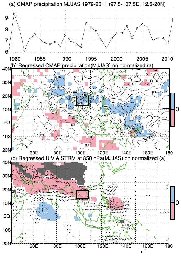
Fig. (a) Precipitation time series generated from theCMAP dataset for the rainy season (May–September) over the reference region of Indochina (12.58–208N, 97.58–107.58E) from 1979–2011. The reference region is used for the regression analysis in (b),(c) and is indicated by a solid rectangle in these panels.
(b)Regression ofCMAPdata during the rainy season against the normalized data (mmday21) shown in (a) from 1979 to 2011. (c) As in (b), but for the 850-hPa zonal and meridional winds and streamfunction (colors) during the rainy season. Areas with colors in (b) and plotted vectors (winds;ms21) and contours and colors (streamfunction; 106m2 s21) in(c) are statistically significant at the 90% level, as determined by correlation coefficients based on 31 degrees of freedom (df).
- The atmospheric circulation patterns that were responsible for the heavy flooding that occurred in Thailand in 2011 are examined.
- Cyclonic anomalies and more westward-propagating TCs than expected from the climatology of the area were observed in 2011 along the monsoon trough from the northern Indian subcontinent, the Bay of Bengal, Indochina, and the western North Pacific, which contributed significantly to the 2011 Thai flood. The strength of monsoon westerlies was normal, which implies that the monsoon westerly was not responsible for the seasonal heavy rainfall in 2011.
- Similar results were also obtained from the 33-yr statistical analysis. The 5-month total precipitation over Indochina covaried interannually with that along the monsoon trough. In addition, above-normal precipitation over Indochina was observed when enhanced cyclonic circulation with more westward-propagating TCs along the monsoon trough was observed.
- The effect of sea surface temperature (SST) forcing over the western North Pacific and the Nino-3.4 region on total precipitation during the summer rainy season over Indochina was unclear over the 33-yr period.

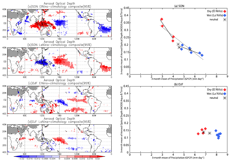
- We statistically investigated an interannual co-variation among aerosol optical depth (AOD), cloud effective radius (CER), and precipitation, focusing on aerosol-cloud interaction over the tropics.
- A three-month composite analysis based on El Niño-Southern Oscillation (ENSO) phases during September–October–November (SON) and December–January–February shows that an increase (decrease) in AOD in the El Niño (La Niña) years was associated with a decrease (increase) in precipitation, particularly in SON over the Maritime Continent. Additionally, CER decreased in the El Niño years over the same region.
- Interannual variation in AOD and CER in SON in the Maritime Continent was asymmetrical, which can be explained by stronger aerosol-cloud interactions under drier conditions. Specifically, large amounts of aerosols suppressed cloud and precipitation formation, which leads to decreases in wet deposition and increases in emission under warmer and drier surface conditions. This feedback results in asymmetrical variation.

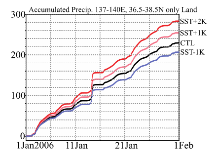
- A regional climate model having a resolution of 4.5 km was used to examine the sensitivity of precipitation on the Japan Sea side of Japan to the sea surface temperature (SST) in the Japan Sea during winter. We performed a control simulation (CTL) driven by reanalysis and observational SST datasets. Three sensitivity experiments in which SSTs over the entire domain were 1K, 2K, and − 1K different from the CTL SST were conducted to examine the sensitivity of precipitation to SST.
- The calculated precipitation on the Japan Sea side increased by 6-12 % per K of SST warming. Concurrent with the precipitation changes, latent heat flux over the Japan Sea increased by 11-14% per K of SST warming. Because the changes in surface relative humidity were very small, the increase can be explained by the Clausius-Clapeyron equation. The deviation from the 7% increase in latent heat flux calculated from this equation can be quantitatively explained by the development of the planetary boundary layer over the Japan Sea, which was related to an increase in sensible heat flux due to the SST warming.
- This result also implies that the 1 K uncertainty in simulated and projected SST over the Japan Sea among multiple atmosphere-ocean global climate models corresponds to an approximately 10% uncertainty in precipitation on the Japan Sea side of Japan.

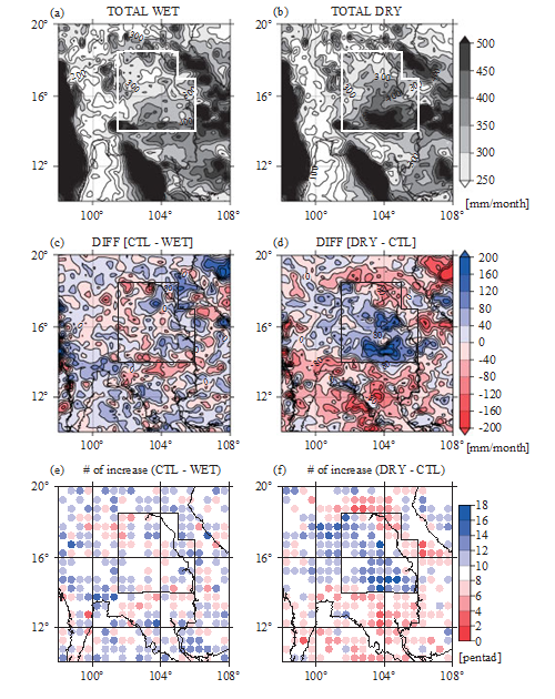
- This study examined the impact of changes in land surface conditions on regional climate over Indochina using a high-resolution regional climate model. Anthropogenically induced land surface changes are going on in this part of tropical Southeast Asia.
- We performed a control simulation (CTL) driven by reanalysis data combined with current land use and predicted soil moisture data. Two sensitivity experiments, assuming wetter and drier land surface conditions over the Khorat Plateau (northeast Thailand) compared with the current land surface condition, were conducted and examined the impact of land surface changes on precipitation.
- The results indicated that drier land surface conditions increased precipitation over the disturbed region. A pronounced increase in precipitation was found only during nighttime, which coincided with the peak in the climatological diurnal precipitation cycle. Drier conditions intensified the diurnal variation of precipitable water associated with the thermally induced local circulation responsible for a horizontal gradient of near-surface temperature. The effects of land use and land cover changes in the tropics are shown to be strongly related to the diurnal precipitation cycle.

- Precipitation variation on various time-scales (Diurnal, intraseasonal, seasonal, interannual and long-term)
- Land-atmosphere interaction (Land-use changes, deforestation, urbanization)
- Air-sea interaction
- Water vapor variation
- Aerosol-cloud-precipitation interaction